Last updated on 20 January 2026
A neighborhood without a roundabout. A commercial area that does not yet exist. Fields instead of subdivisions. With his online service Going back in time, the National Institute for Geographical and Forestry Information (IGN) offers incredible access to the history of French landscapes.
To give your students a concrete understanding of urban sprawl, IGN offers an unstoppable visual solution …A free, super powerful public tool that will naturally find its place in history and geography classes.

Table of Contents
Going back in time IGN: exceptional access to French cartographic heritage
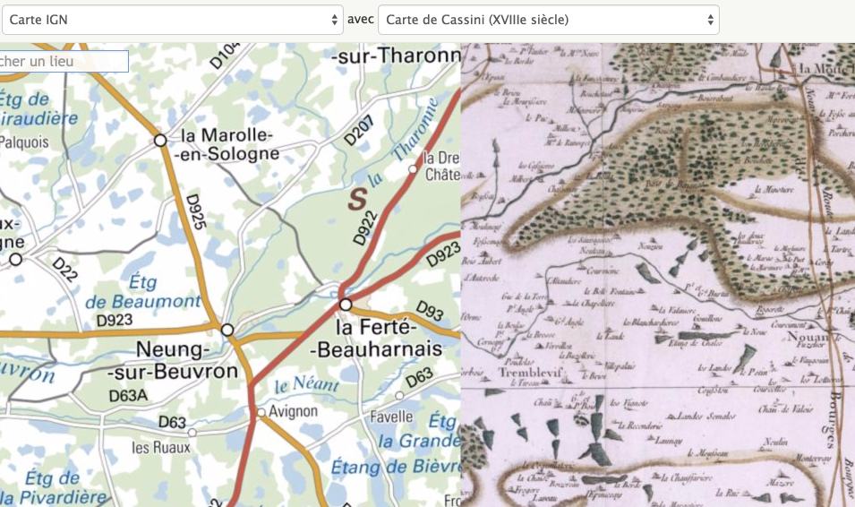
Behind its sober interface, the service gives access to a considerable documentary mass. The main historical maps – Cassini map in the 18th century, 19th ᵉ staff maps, first generations of IGN maps – but also a collection of several million aerial photographs, resulting from regular campaigns carried out since the 1920s. Today, few resources make it possible to observe nearly a century of territorial development with such a level of continuity.
Visualising the evolution of a place: an immediately speaking experience
The strength of Going back in time is due to its ability to make visible what is often abstract in textbooks. The comparison mode allows you to display two eras simultaneously and drag a cursor between them. The effect is immediate: urbanisation is obvious, infrastructure is emerging, natural areas are shrinking, and some neighbourhoods are emerging almost ex nihilo.

For students, this visualization changes the very nature of observation. They are no longer just reading a map: they are witnessing the gradual transformation of a territory. Periurbanisation, the artificialisation of soils, the transformation of agricultural areas or the evolution of coastlines are becoming concrete, visible and debatable realities.
Concretely, it is enough to enter the name of a municipality or place to see the different layers available. Depending on the territory, we can compare the same space to ten, twenty or sometimes thirty different dates. The richness of the base immediately gives an idea of the project’s ambition: document, in the long term, the evolution of French landscapes.
Ancient maps and aerial photos: documents for working in class
The educational value of the tool also lies in the possibility of download documents. Images can be integrated into a slideshow, printed, annotated, compared in a group work. We then leave the simple demonstration to enter into a logic of work on sources.
Students manipulate real archival documents, learn to describe what they see, compare, formulate hypotheses.
The richness of the cartographic fonds of the National Geographic Institute
The IGN, which did not wait for Google to create and offer a high-quality map, did a great deal for this service integrated into its portal.
You'll be able to Playing with cards. The screen divides in two in height or horizontally you choose. Side by side or face to face the same place mapped at two different times. Instructive. You can move the map at the tip of your mouse, the two previews will move at the same time. You can also use magnifying glass vision to browse a map. The old version of the map will then appear in the centre of your magnifying glass when you browse the map with it. Magical.

It is of course possible to zoom in on a place. This site dating back to the time of the IGN makes it possible to compare IGN maps, maps at 1/50000 of 1950, maps of the 1820/1860 General Staff, Cassini map of the 18th century, as well as aerial views of today and aerial photos taken in the 1950s. You can combine all this data as you see fit.
Complete functions to go further
The tool remains accessible without complex handling, but it offers enough functionality to build real pedagogical activities. Some of the most useful functions in the school context include:
-
search by location or address to quickly access a territory known to students,
-
the choice of cartographic or photographic layers by period,
-
the mode of comparison with cursor to visualize two epochs simultaneously,
-
the transparency setting to overlay documents,
-
downloading maps and snapshots for offline use in the classroom,
-
sharing a view by simple link, convenient for an ENT or digital medium.
The tool can be used for both quick demonstration and more structured multi-session work.
![]() Read also / 5 geographic gaming sites to have fun with maps.
Read also / 5 geographic gaming sites to have fun with maps.
A strong educational tool for history and geography
Beyond the richness of the maps, it is the reliability of the tool that seduces. With the NG we are confident. Unlike many free apps that can disappear or become paid overnight, this machine go back in time to the IGN is a strong institutional resource.
Free of charge, without advertising, without registration and respectful of data: Going back in time is a safe bet on which you can build your history-geography sequences without fears. A beautiful online tool very simple to use and perfectly suited for use in class. An essential to slip into your favorites.
This time machine proposed by the IGN is limited, but it is already quite good, to French territory.