Last updated on 12 May 2026
The rise of digital technologies has led to the proliferation of online maps and geospatial information. Creating a geo-referenced map is an invaluable skill for anyone working with spatial data, whether professionally or personally. An online map is a type of interactive and dynamic virtual map that can be viewed online rather than as a printed document. A online map can be created in many ways, depending on your resources and desired outcome. There are many free online mapping services, but the best of them usually charge you for use or impose limits on their free service.

However, online maps are an excellent educational tool and a good way to present information in an attractive and interactive way. They can be used to present statistical data, travel itineraries, historical information. You can also start creating custom maps.
I suggest you discover a brand new tool for creating an online map: Felt. Remember his name, it’s probably one of the best ways to make cards on the Internet and all for free. Discovery.
How to create a map on the Internet?
Felt is a great way to create and Maps on the internet, then share them. Whether presenting a historical fact, visualising geographical data or simply preparing a school trip, Felt’s drawing tools make mapping easy and fun. Felt allows you to explore data, collaboratively edit maps in real time and share a map with a single click.
The tool offers you a large number of background maps of the planet that you will be able to use to create your personalised map. Felt will then allow you to edit it as if it were a block of paper. The tools at your disposal are taken care of immediately and without instructions for use. You can write, draw, surround, you can add links, photos, videos … Everything is done smoothly and without any difficulty.
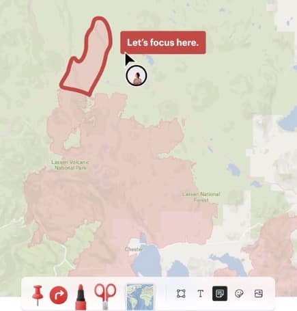
Felt also offers smart mapping tools, such as Route and Clip, that make it possible to draw along roads and borders in the blink of an eye. We are very far from some heavy and complex professional tools, Felt is intuitive, simplicity for results that do not have to envy more reputable toolboxes.
Felt comes with an integrated library of over 50 layers of data, handpicked to be reliable and of high quality. The tool surprises by its ease of use but also by its speed. The data loads at lightning speed. While classic Internet maps sometimes take several tens of seconds to load after each pan and zoom, Felt loads in less than 300ms.
Work with others and share your maps
Felt facilitates the creation of online maps, it also facilitates their sharing. Each card has a unique link, for a simple email sharing with your team, your students, or the general public. You can also embed them on your site or share them via social networks.
The platform integrates and will develop the possibility of achieving a collaborative work on the cards. The live multi-authored edition is integrated. You will be able to invite whoever you want to come and work together on a live map in real time.
Felt works on a computer, but also on a tablet and even on a smartphone. If you need to create a map online, a test is required. You will be surprised by its simplicity and agility in bringing your data to life. Another surprise and not least, Felt is completely free and without any advertising for personal use.