Last updated on 12 May 2026
A journey through history and an all-round journey with Orbis an astonishing mapping tool offered by Stanford University. Orbis is a kind of ancient Google Maps that manages all the roads of the Roman Empire.
This somewhat unusual service makes it possible to plan a journey through the Roman Empire using the roads built more than 2000 years ago. An antique GPS that will allow you to better program your trip whether you travel on foot, on horseback, in a chair with porters or in a carriage … Bon voyage.
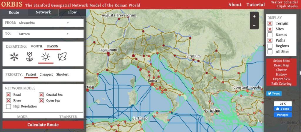
A map of all roads in the Roman Empire
The Roman Empire is known for its expansionism and military conquests. He is also known for building a unique network of roads to connect the four corners of the continent. Land roads, rivers, shipping routes have allowed an essential and absolutely incredible mesh that Stanford researchers make us discover through Orbis.
Slip into the shoes of a Roman traveller two thousand years ago. You are in "Lugdunum" and plan to go to "Roma". Which road or Roman road to take? How long will it take you? Where to take the step? How much will it cost you? All possible and imaginable responses and variables are in Orbis.
A real Google maps of the Roman roads
The use ofOrbis, even if the interface is in English, is quite simple. You choose on the map your starting point and then your arrival point. As soon as the application draws all possible variants of journeys.
Where Toutatis makes this quite incredible is in the possibilities of personalising your trip. You will be able to choose the season of departure, it will play on the necessary time. But you can also, as in our modern applications, give priority to the shortest, fastest or cheapest …le journey.
On your Roman GPS you can still opt for the type of lane you agree to take. You will have to choose your means of transport: (on foot, on horseback, in porter, at military pace, etc.) the average of kilometers traveled per day will not be the same. By the way, one learns that the Roman military had a pretty average of 60 km per day …
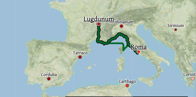
For your little getaway to Rome the cheapest route in January will be 1311 km long. It will take you a little more than 15 days to travel the distance.
A great tool from Stanford University for a unique and fun journey back in time.
We like cards in Stanford, they were also the ones who had “amused themselves” to recreate the largest and oldest map in the world.
If you are interested in mapping and in particular narrative mapping, I refer you to the article that lists the main tools of narrative mapping.

1 Response
[…] if you like amazing trips, I recommend this other site for a great, very big trip in the […]